As an Amazon Associate, we earn from qualifying purchases. Some links on this site are affiliate links at no extra cost to you. Our recommendations are based on thorough research and editorial judgment.
How Flight Altitude Affects Ground Resolution
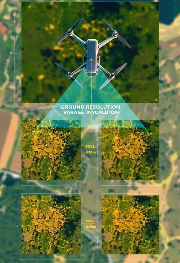
Flight altitude plays an essential role in determining a drone’s Ground Sampling Distance (GSD), which in turn affects image clarity and detail. Lower altitudes (10-30 meters) provide a GSD of 0.27 to 0.82 cm, perfect for detailed inspections. At medium altitudes (50-80 meters), GSD ranges from 1.37 to 2.19 cm, suitable for construction monitoring. Conversely, higher altitudes (100-120 meters) result in a GSD of 2.74 to 3.29 cm, sacrificing detail for broader coverage. We can explore these dynamics further.
Key Takeaways
- Ground Sampling Distance (GSD) improves with lower flight altitudes, offering 1-2 cm per pixel for high-detail applications.
- Medium altitudes (50-80 meters) yield a GSD of 1.37 to 2.19 cm, suitable for monitoring construction sites.
- Higher altitudes (100-120 meters) compromise detail, resulting in GSDs of 2.74 to 3.29 cm, ideal for mapping larger areas.
- For volumetric analysis, maintaining a GSD of 2.5 cm or better is crucial at a flight altitude of 122 meters.
- Balancing altitude with required detail is essential for operational efficiency and effective drone utilization.
Understanding GSD and Ground Resolution
When we talk about how flight altitude affects ground resolution, one of the first things we should understand is Ground Sampling Distance, or GSD. Simply put, GSD tells us how much ground area each pixel in our drone images covers, which directly impacts the clarity and quality of those images.
If you fly lower—let’s say between 10 to 30 meters—you can achieve a GSD of around 0.27 to 0.82 cm per pixel. This level lets you capture tiny details, which is perfect for jobs like inspecting a bridge or a roof where precision is key. On the other hand, if you pull up to a medium altitude of 50 to 80 meters, the GSD ranges from 1.37 to 2.19 cm per pixel. Here, you’re finding a sweet spot where you still get good detail while covering more ground—ideal for checking the progress of a construction site.
Now, if you’re at higher altitudes, like between 100 and 120 meters, the GSD increases to 2.74 to 3.29 cm per pixel. While this is handy for surveying large areas, you do lose some measurement accuracy. Ultimately, the altitude you choose really hinges on what you need from your project. Are you after crisp details or broader coverage? It’s all about balancing those priorities as you set your drone’s flight path.
Many aerial imaging drones also incorporate advanced stabilization systems like 3-axis brushless gimbals, which help maintain image clarity regardless of flight altitude.
How Altitude Impacts GSD for Drone Surveys?
Hey there! Let’s chat about how altitude really affects Ground Sampling Distance (GSD) when flying drones for surveys. Basically, GSD tells us how much detail we can capture in our images. When you fly your drone lower, say between 10 to 30 meters, you can get a GSD of about 0.27 to 0.82 cm per pixel. This level of detail is fantastic for capturing intricate features, like the textures on a building or the markings on a sports field.
When you raise your drone to a medium altitude of about 50 to 80 meters, the GSD adjusts to between 1.37 and 2.19 cm per pixel. This is often the sweet spot for things like construction monitoring, where you want a solid view of the site without needing that ultra-fine detail. But if you take your drone higher—around 100 to 120 meters—the GSD ranges from 2.74 to 3.29 cm per pixel. At this altitude, you start losing some of that detail, which isn’t ideal for precision work like surveying land for agriculture.
Choosing drones with features like 4K Ultra HD cameras helps maximize image clarity at various flight altitudes.
Recommended Products

Sony USA Authorized. Bundle Includes: Sony FX6 Digital Cinema Camera Kit with 24-105mm Lens + Sony FE 70-200mm f/2.8 GM OSS II Lens, Sony 160GB CFexpress Type A TOUGH Memory Card, Sony BP-U35 Battery, 3 Piece Filter Kit, Graduated Color Filter Kit, Tulip Lens Hood, Large Bag, Memory Card Wallet, Cleaning Kit, HDMI Cable, Lens Cap Keeper

Items Included: 1 x Sony FX6 Full-Frame Cinema Camera (Body Only), 1 x Large Bag, 1 x Memory Card Wallet, 1 x Cleaning Kit
Advanced Triple-Camera System - The Mavic 4 Pro’s Infinity Gimbal features a triple-camera system: a 100MP Hasselblad wide-angle lens with 6K60 HDR and HNCS color, a 48MP medium tele for portraits, and a 50MP tele for sharp long-range shots. All support up to 4K slow motion (4K120 on wide/medium, 4K100 on tele), dual native ISO fusion, 10-bit D-Log, RAW frame stacking, and intelligent modes like Panorama and Subject Focusing—delivering professional results in any setting.
Optimal Altitudes for Different Drone Applications
When it comes to drone applications, finding the right altitude can make a world of difference in the quality of your imagery. Each task calls for a different approach, and understanding these details can really enhance your results. For example, if you’re doing a critical inspection of infrastructure, flying the drone at about 10 to 30 meters is ideal. This altitude gives you a sharp Ground Sampling Distance (GSD) of just 1 to 2 cm per pixel, allowing you to spot even the smallest issues.
On the flip side, if you’re monitoring a construction site, consider flying at a height of 50 to 80 meters. This strikes a nice balance between detail and ease of processing, achieving a GSD of approximately 1.37 to 2.19 cm per pixel. It gives you enough detail to assess progress without overwhelming yourself with data. For broader tasks like mapping large areas, you’ll want to go higher—about 100 to 120 meters—to get a GSD of around 2.74 to 3.29 cm per pixel.
And don’t forget about volumetric analysis! Here, flying at 122 meters ensures your GSD stays at or below 2.5 cm, making your measurements accurate. Basically, the right altitude not only helps with capturing great images but also maximizes your flight time, keeping those drone batteries happy. Drones with features like dual battery setups are especially useful for prolonged aerial projects, enabling uninterrupted shooting. With this altitude knowledge in your toolkit, you’ll be well-equipped for your next aerial project! Now, let’s explore some tips on selecting the best drone for specific tasks.
Recommended Products

DJI FPV FLY MORE KIT: It is designed for those who want to extend and guarantee the flight time of their drone, thanks to the two smart batteries and the multiple charging station included
![FUNSNAP Diva -Drone Quadcopter UAV Compact & Foldable Pocket Drone , 2-Axis Gimbal with Camera for 4K Video & 12MP Photo, 30mins Flight Time, 5.8G WIFI & FPV Shooting ,One Key Take Off/Landing[Double Battery Pack]](https://m.media-amazon.com/images/I/31ua000i39L._SL500_.jpg)
[Light & Free] Almost the size a regular smart phone (folded) and weighing only 280g/0.62lbs, DIVA is one of the smallest drone ever, one that you can actually carry around and use on a daily basis, just like your cell phone. Now you can pack light and travel free.

Authentic and brand new, suitable for Matrice 30 Series.
How GSD Relates to Detail and Coverage in Drone Applications
Hey there! So, let’s talk about Ground Sampling Distance, or GSD, and why it matters for our drone imagery. Essentially, GSD tells us how much ground each pixel in our photos represents. A lower GSD means we get more detail—think of it like zooming in really close on a picture. For precision jobs, like mapping out a small plot of land or capturing intricate details of a building, we want a GSD of about 1-2 cm per pixel. You can usually get that kind of resolution when you’re flying your drone at altitudes between 10 to 30 meters.
Now, if your project involves covering a larger area, like surveying a whole farm, you might find yourself flying at around 100 to 120 meters. At that height, the GSD increases to about 2.74-3.29 cm per pixel. While this is great for giving you a broad view, it does lose some of that sharp detail. For specific tasks like measuring stockpile volumes, you often need a GSD of 2.5 cm or better, typically achieved at about 122 meters. It’s all about balancing the detail you need with the area you want to cover. Understanding this can really help streamline your drone projects. Now, speaking of projects, have you considered what specific tasks you might tackle with your drone?
Keep in mind that choosing a drone with advanced stabilization technology can also enhance the clarity and accuracy of your aerial images.
Advantages of UAV Imagery Over Traditional Aerial Photography
When we think about aerial photography, we often picture those classic shots taken from planes or helicopters, right? But have you considered how UAV imagery is changing the game? Drones can capture images with amazing detail—like 1-2 cm per pixel—even when flying at lower altitudes. This level of clarity is fantastic for projects where you need that close-up perspective, like surveying a construction site or mapping out landscapes.
One of the coolest things about UAVs is their ability to handle tricky weather conditions, such as clouds or wind. Traditional aerial photography can get pretty shaky and blurry when the weather isn’t cooperating. But modern drones have advanced stabilization tech that keeps everything steady, resulting in sharp images. For instance, if you’re capturing agricultural data, a drone can fly close to the crops, ensuring you get crisp details without the motion blur that sometimes plagues helicopters.
Plus, drones can be programmed to fly specific paths and can quickly process images on the spot. This means you can adjust the camera settings on the fly and ensure you get the best shots possible. Think about it—when you’re working on something that requires precise information, like environmental monitoring, those tailored images make a world of difference.
Many interval shooting drones come equipped with advanced stabilization features such as 3-axis gimbals and electric image stabilization, ensuring smooth and clear aerial footage even under challenging conditions.
Recommended Products
Equipped with a Hasselblad L1D-20c camera with a 20MP 1” CMOS Sensor, the Mavic 2 camera drone lets you capture gorgeous aerial shots in stunning color detail.

Equipped with a Hasselblad L1D-20c camera with a 20MP 1” CMOS Sensor, the Mavic 2 camera drone lets you capture gorgeous aerial shots in stunning color detail.
【Impressive 10000FT Long Range & 5G FPV Transmission】: Control this GPS drone from up to 10000 feet away with crystal-clear 5G real-time FPV feed on the 4.5" HD screen remote – great for exploring vast areas while seeing exactly what the drone with camera sees.
Recent Advances in Drone Technology and Their Significance
Hey there! Have you noticed how advancements in drone technology are completely changing the way we do aerial surveying? These modern drones are equipped with cutting-edge sensors that capture really clear images from the sky, resulting in better data for us to work with. For example, a drone with a high-resolution camera can reduce what we call the Ground Sampling Distance (GSD), which means we’re getting sharper and more detailed images.
What’s even cooler is that these drones have advanced flight systems that help them stay steady in the air, even if the weather isn’t perfect. Imagine trying to take a photo on a windy day—it’s tough! But with these high-tech drones, you get consistent images without all that shaking. Plus, they come with smart AI tools that can automatically adjust the flight settings, like altitude and speed, based on what’s happening around them.
This means they can make real-time decisions to optimize their performance. Think about it: if a drone detects unexpected weather patterns, it can change course or adjust height to ensure it’s still collecting the best data possible. And with user-friendly platforms, teams can collaborate effectively, share data easily, and analyze results comprehensively.
Additionally, features like Electronic Image Stabilization significantly enhance the quality of video streaming and image capturing during drone flights.
Finding the Right Altitude for Your Drone Project
When it comes to making our drone projects really effective, one of the key factors to consider is choosing the right altitude. This decision is crucial because it directly affects our Ground Sampling Distance, or GSD, which is all about how detailed the images we capture will be. For example, if we’re inspecting a bridge or some intricate infrastructure, flying at a lower altitude—say between 10 and 30 meters—gives us an impressive GSD of about 1-2 cm per pixel. This means we get super detailed images that allow us to spot even the smallest issues.
On the flip side, if we’re monitoring construction sites, we might want to balance detail with the need to cover more ground. In this case, flying a bit higher, around 50 to 80 meters, offers a GSD of 1.37 to 2.19 cm per pixel, which still provides good detail while being more efficient. And if our goal is to survey a larger area, we can go even higher, between 100 and 120 meters, resulting in a GSD of 2.74 to 3.29 cm per pixel. Just remember, while this gives us a broader view, we do lose some of the fine detail.
Ultimately, taking a moment to think about the specific needs of our project will help us find that perfect altitude, letting us strike a great balance between image detail and operational effectiveness. And once we’ve got that sorted, we can move on to planning our flight paths for the best results! Choosing drones with features like a 3-axis gimbal can further enhance image quality by reducing shake during flight.
Recommended Products

Integrated X5 camera features 3-axis stabilization and records 4k video in h.264 and 16MP stills in both .JPG and .DNG raw
Hasselblad Main Camera - Mavic 3 Pro has a 4/3 CMOS sensor, 24mm format equivalent, f/2.8-f/11, 20 MP. The Hasselblad 4K drone camera supports shooting RAW photos with a dynamic range of up to 12.8 stops.

Imaging Above Everything - With a 4/3 CMOS Hasselblad Camera, the sensor provides a 12.8-stop dynamic range that retains more details in highlights and shadows, upgrading your work to a professional level..Min focal length : 12
How Anvil Labs Enhances Ground Resolution Monitoring
You know, finding the right altitude for capturing images isn’t just about getting that stunning shot—it’s about making sure those images are genuinely useful for analysis. At Anvil Labs, we focus on ground resolution monitoring, which means we use some pretty advanced aerial data management tools. This helps us capture crystal-clear imagery with our top-notch cameras while also ensuring that we achieve the best Ground Sampling Distance (GSD) for each project.
For instance, if we’re monitoring agricultural fields, a closer altitude allows us to capture detailed images of crops, highlighting areas that may need more attention. This way, farmers can make more informed decisions about their land. And if we’re surveying urban areas, we can zoom in on construction sites to track progress closely, providing valuable insights to project managers.
To maximize effectiveness, it’s crucial to choose equipment with optimal signal reception, ensuring data transmission is both reliable and clear.
Recommended Products

👍【REACH NEW FRONTIERS】Autel Robotics EVO Max 4T V2 perfectly integrates a wide camera, Zoom Camera, L~aser R~angefinder, and T~hermal Camera. Ultra-sensitive wide-angle camera supports 48MP 1/2" CMOS, max ISO 64000, Moonlight Algorithm 2.0 allows capturing crisp even in low-light environments. Zoom Camera supports 48MP 8K 10x optical zoom (160x Max). L~aser R~angefinder's Measuring Range: 16.4–3737 ft, Measuring Accuracy: ± (1 m + D×0.15%). T~hermal Camera with 640*512 30Hz t~hermal imaging and 9.1mm focal length and 16x digital zoom.

🥇【WHY CHOOSE US?】Every product we offer is sourced directly from Autel’s factory and is 100~% or.i.ginal. Autel EVO 2 Dual 640T Enterprise V3 sold here is not only covered by Autel Store’s af.ter-sa.les service, but also includes a US.-based war.ra.nty for timely and dedicated su.p.port.💝This bundle is backed by 30 Days REP~LACEMENT or F.U.LL R~E.FUND, 12 Months f-r.e.e from defects services. Any issues, please co.nt.act📩 AutelStoreOnline @ outlook . com📩
🏆【AUTEL ROBOTICS USA AUTHORIZED】We are the longest and largest distributors of Autel Robotics. Over the years, we have maintained a close partnership with Autel, providing customers with high-quality products and excellent tech service. With extensive experience and strong technical expertise in this industry, we are able to offer customized solutions and professional technical support to our customers. All the products we offer include FULL USA WA-RRANTY. Pls contact 📧autelofficial @ outlook . com📧
Frequently Asked Questions
How Does Altitude Affect Ground Speed?
Isn’t it funny how higher altitudes can actually slow our drones down? Ground speed varies considerably with altitude, and its impact isn’t always what we expect. Let’s explore how this affects our flying experiences together!
Does 1000 Ft Elevation Make a Difference in Breathing?
At 1,000 feet, we generally won’t experience breathing difficulty, as oxygen levels drop slightly without significant impact. However, those engaging in vigorous activity might notice a bit more cardiovascular strain than at sea level.
Does the FAA Know if You Fly Above 400 Feet?
So, we’re not exactly on the FAA’s radar, but let’s keep our drone operations below those altitude limits. Just imagine a fine-toting drone police swooping down, ready to enforce regulations—no thanks!
What Is Ground Sample Distance and How Is It Affected by the Altitude of an Aircraft?
Ground Sample Distance (GSD) defines pixel area in aerial imagery, affecting ground resolution. As altitude increases, GSD worsens, leading to lower detail. We must choose ideal altitudes to achieve the best outcomes for our projects.