As an Amazon Associate, we earn from qualifying purchases. Some links on this site are affiliate links at no extra cost to you. Our recommendations are based on thorough research and editorial judgment.

What Is Orthomosaic Imagery and Its Applications
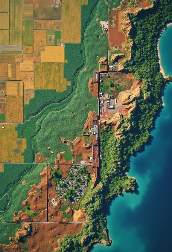
Orthomosaic imagery gives us an accurate view of the Earth’s surface by stitching together high-resolution aerial photos. This technology is invaluable in numerous fields like agriculture, urban planning, and environmental monitoring. Its applications range from crop tracking to enhancing public safety during disasters. Unlike traditional maps, orthomosaic images provide precise measurements and real-time analysis, facilitating better decision-making. Interested in discovering how we create these detailed maps and their specific benefits?
Key Takeaways
- Orthomosaic imagery combines aerial photos into a high-resolution, geometrically corrected map for accurate spatial analysis.
- It enhances decision-making across various fields, including construction, real estate, and environmental monitoring.
- The creation process involves drone flight planning, image stitching with photogrammetry software, and use of Ground Control Points for accuracy.
- Real-time monitoring allows for centimeter-level precision, surpassing traditional mapping methods reliant on manual survey techniques.
- Applications span urban planning, disaster response, and agricultural monitoring, providing detailed visualizations for improved project execution.
What Orthomosaic Imagery Is and How It Works?
Hey! Have you ever heard of orthomosaic imagery? It’s really cool! Essentially, it’s a type of aerial photography that brings together tech and mapping to create super detailed images from the sky. Imagine grabbing a bunch of high-resolution photos with a drone and then stitching them into one large, smooth picture that’s also tagged with geographical info!
The secret sauce in this process is something called photogrammetry software, which helps keep everything at a uniform scale. This means that if you want to measure distances or areas, they’ll be spot on. To make sure everything is as accurate as possible, photographers often use Ground Control Points (GCPs). These are specific locations on the ground with known coordinates that help fine-tune the mapping process.
People use orthomosaic imagery for all sorts of practical things. For instance, farmers can monitor the health of their crops, while construction teams can track the progress of their projects over time. It really changes the way we analyze landscapes and environments. Whether you’re curious about agricultural efficiency or just love the idea of high-tech mapping, it’s a fascinating field that opens up so many possibilities! Many professionals benefit from the precise display technology of modern monitors to view and analyze these images effectively.
Key Differences Between Orthomosaic Imagery and Traditional Mapping Techniques
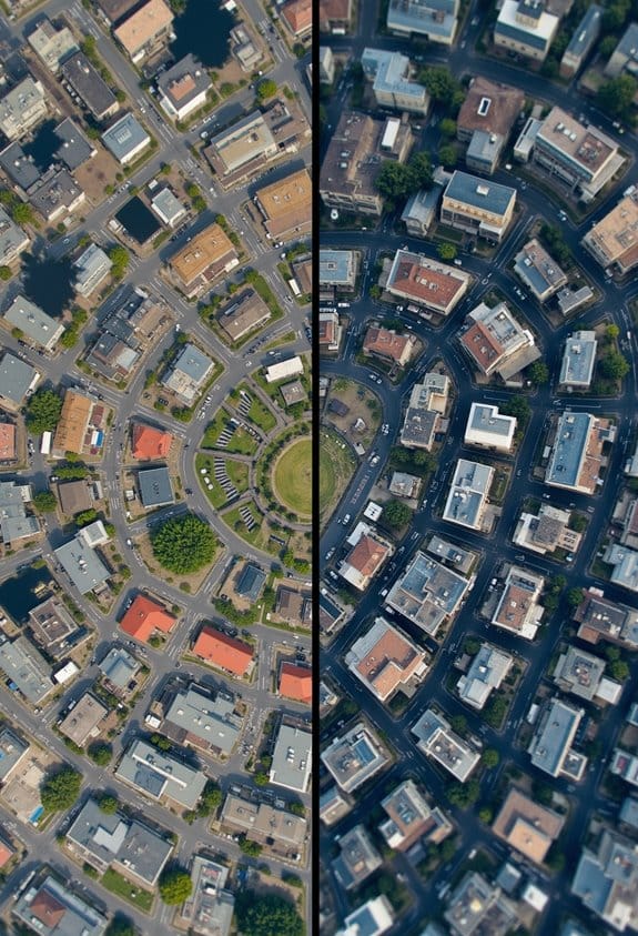
Hey there! Have you ever heard about orthomosaic imagery? It’s pretty fascinating how it differs from traditional mapping techniques. For starters, traditional maps usually depend on ground surveys and manual measurements, which can be quite labor-intensive. In contrast, orthomosaic imagery offers a geometrically corrected, bird’s-eye view of the terrain, thanks to advanced photogrammetry technology.
Imagine being able to take a series of high-resolution photos of an area and automatically stitch them together to create a detailed map. That’s precisely what orthomosaics do! They let us monitor land use or construction projects in real-time, unlike older methods that might take days or even weeks. Plus, the uniform scale of orthomosaic maps makes calculating distances and areas super accurate, compared to traditional methods that can sometimes throw off numbers.
And here’s a cool fact: orthomosaics can achieve centimeter-level accuracy, which is way more precise than most traditional maps. This makes them invaluable for projects where exact measurements matter. Overall, orthomosaic imagery really enhances how we understand and interact with our environment. Many professional applications leverage drones equipped with high-resolution cameras to capture the detailed imagery needed for creating orthomosaics.
Ready to dive into how these images are created? Let’s explore that next!
Key Industries Benefiting From Orthomosaic Imagery
You know, orthomosaic imagery is fascinating because it’s being used in so many different fields! Take construction, for example. With orthomosaic imagery, project managers can get precise measurements of a site and track how construction is progressing over time, making it way easier to keep everything on schedule.
Real estate agents are also jumping on this trend. They use high-resolution aerial images to highlight properties and landscapes, almost like giving a virtual tour from above! This not only shows off the property but helps potential buyers visualize what it could be like to live there.
Public safety agencies find orthomosaic imagery super helpful too. When disaster strikes, they can map out affected areas quickly. For instance, during a flood, emergency responders can assess damage and plan their recovery efforts based on accurate aerial images.
Don’t forget about environmental monitoring! Researchers use this imagery to keep tabs on changing ecosystems and track wildlife populations. It’s crucial for understanding how our environment is shifting.
Isn’t it amazing how a single technology can benefit so many different areas? As we continue to explore its applications, we’ll uncover even more intriguing uses for orthomosaic imagery! Many of these applications are enhanced by drones equipped with electronic image stabilization, ensuring smooth and clear aerial shots.
How Orthomosaic Imagery Enhances Decision-Making in Urban Planning and Agriculture
Have you ever wondered how modern technology is shaping the way we plan our cities and manage our farms? Well, high-resolution orthomosaic imagery is a perfect example of this! These detailed maps give us a bird’s-eye view of land use, allowing urban planners to see exactly how spaces are being utilized and how construction projects are progressing.
For instance, if a new park is being developed, planners can easily monitor its impact on the surrounding environment and ensure that everything aligns with zoning laws. In agriculture, farmers use orthomosaic imagery combined with various types of data to assess crop health. This means they can spot issues like pest infestations or nutrient deficiencies much earlier. For example, if a farmer notices a specific field shows signs of stress in the imagery, they can apply targeted treatments to that area rather than treating the whole farm, saving both time and resources.
In essence, these high-resolution maps provide important insights that lead to smarter decision-making in both urban environments and agricultural practices. The integration of drones equipped with 4K resolution cameras significantly enhances the detail and accuracy of this imagery, making the data more actionable. As we explore further, we can uncover how these tools are not just enhancing efficiency but also fostering sustainability in our communities and food systems.
Steps for Creating Orthomosaic Maps: From Data Collection to Analysis
Hey there! So, let’s talk about creating orthomosaic maps. It’s pretty fascinating how it all comes together through a series of intentional steps. First, we need to plan the drone flight very carefully. We decide the best route, how high the drone should fly, and make sure we have enough overlap between the images we’ll be capturing. Think of it like creating a giant puzzle; if the pieces don’t fit well, the picture won’t look right!
When the drone is up in the air, it snaps a bunch of overlapping photos directly below it using high-resolution cameras. Imagine taking a series of photos of your backyard from above, aiming for each shot to overlap with the last—this helps to create a comprehensive view. Once we have all those images, we bring them back to the computer, where some pretty clever photogrammetry software comes into play. It stitches all those photos together and adds geographic information to create a single, detailed mosaic.
But we’re not done yet! We then perform orthorectification, which might sound technical, but really, it just means we’re fixing any distortions caused by hills or varying camera angles. This ensures the final image looks as if you’re looking straight down from above, without any weird tilts or bends. After that, we go through a quality check to make sure everything is accurate. Once that’s done, we’re ready to analyze the spatial data for various uses, like land planning or environmental monitoring.
And trust me, seeing the final orthomosaic is incredibly rewarding—it really shows the beauty and complexity of the area you’ve mapped out. It’s like having a bird’s-eye view of the world that can inform decisions and enhance projects! This process opens the door to a whole range of possibilities for using this data effectively. For organizing and protecting the equipment used in such projects, choosing polypropylene cases can ensure durability and convenience throughout fieldwork and storage.
Frequently Asked Questions
What Is Orthomosaic Imagery?
We’ve created compelling visuals using drone technology and aerial photography. Our image processing techniques enhance geographical mapping, delivering high spatial resolution for data analysis and remote sensing, perfect for diverse mapping applications and accurate visual representation.
What Is an Orthomosaic and How Is It Made?
An orthomosaic’s made using drone photography, image stitching aerial surveys. We guarantee data accuracy by employing GIS applications and surveying methods, which enhance spatial analysis for landscape modeling and crop monitoring, providing precise mapping techniques.
What Is Orthographic Imagery?
Think of orthographic imagery as a bird’s-eye view, transforming aerial photography into precise topographic maps. It enhances geospatial analysis, ensuring data accuracy for land use, environmental monitoring, and effective surveying techniques like crop assessment.
What Is the Main Function of an Orthomosaic Map?
The main function of an orthomosaic map is accurate mapping, aiding urban planning, agricultural assessment, environmental monitoring, and more. It supports construction management, land surveying, wildlife tracking, disaster response, resource management, and archaeological research effectively.